World-class analysis, global range

Street Tree Prioritiser ™
Various Cities, Australia
Growing urban forests is a clear priority in the fight against climate change for nearly every city on the globe, but few cities know how many trees they can plant, where they can plant, and even fewer know where they should plant. The Street Tree Prioritizer is a prioprietary tool developed by EnDev to identify all plantable opportunties across a city and prioritize which opportunities would have the biggest impact on urban canopy, urban heat, and social vulnerability and delievers a prioritized planting schedule based on each cities intended planting rates.

Ecological Corridors Mapping and Prioritization
City of Onkaparinga, South Australia
Preserving any land is good, but preserving priority habitats for keystone species ensures the right lands are protected that will have the biggest ecoystem benefits. By constructing habitat maps for 10 keystone species, this work identified which areas are used by the most species and identifed optimal ecological corridors that would maximize ecological connectivity while maintaining balance between economy and environment.

The future of heat
Urban Cooling Strategy
City of Kingston, Victoria
When satellite thermal data and climate model projections come together to show a warming future, an Urban Cooling Strategy identifies current and future hotspots, and prioritizes where to focus cooling efforts to achieve the most cooling and to decrease impacts of disadvantaged populations. Report available at Council Website:
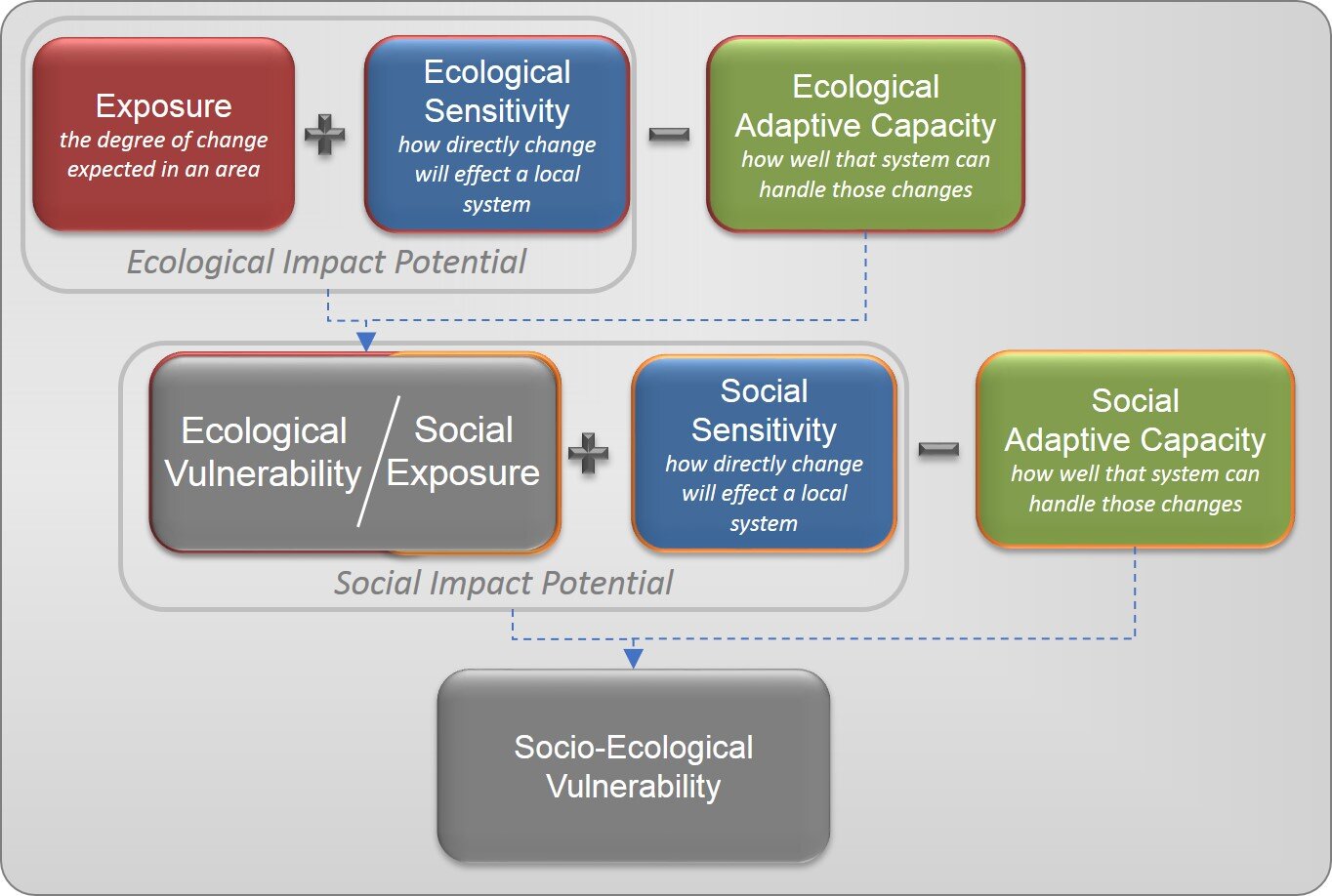
Risk and Vulnerability Conceptual Equation
Climate Change Vulnerability Assessment (CCVA)
RARE Conservation - Washington DC/Global
Bringing spatial data and analysis to help understand what drives vulnerability and what we can do about it. This tailored CCVA strategy engaged 26 indicators to assess the vulnerability of locally managed fisheries and their communities across a global conservation initiative. Dashboad viewable here.

Planting priorities
Urban Forest Strategy
City of Canada Bay, New South Wales
Mapping urban forest assets, projecting future coverage, and developing a strategy to meet future green canopy targets all relies on imagery, data, and spatial modeling to ensure accurate, realistic results. Our work goes beyond just saying you need to plant, to say where you need to plant, and why. Report available, at Council Website.
Infrastructure webmapping
Asset Management and Capacity Assessment
Primary Industries and Resources South Australia (PIRSA)
Estimating future needs requires understanding current demand and capacity. Integrating network facilities, infrastructure, current and potential consumers, and market trajectories, economic projections, and policies shows you where you need to be investing now to be prepared for the future. Interactive web-maps provide street-level detail to help you manage that future.

UAV Data of street cooling treatment
Urban Heat Mitigation Evaluation
South Australia
To combat urban heat, cities are applying road treatments to cool one of the hottest and most prevalent surfaces in the urban environment: streets. State-of-the-art UAV technology and advanced spatial analysis revealed the impact of that cooling while also finding unexpected cooling patterns caused by other unconsidered conditions.

Child-Centered Risk Assessment, Myanmar
UNICEF
In one of the most disaster-prone countries on Earth, advanced geospatial analysis provides in-depth insight into the challenges facing the country's 17 million children. Using integrated GIS processes, this work analyzed 32 indicators to identify the specific areas with the most at-risk children for use in upcoming organizational programming and national government assessments. Webmap viewable here.

Urban Heat map, Interactive web map
Urban Heat Island Mapping - South Australia
Western Adelaide Region
How we use our land affects how we live our lives. EnDev has delivered thermal mapping projects at all scales using satellite and airborne sensors, integrating technical data with social vulnerability and land use information to provide novel analyses and insights that make cities more sustainable, equitable, and viable. Webmap viewable here.
Renewable Energy Mapping, South Australia
ITP Renewables
Tapping new energy resources is inevitable. Sourcing that energy from clean, renewable resources allows us to grow while minimizing our environmental impact. Advanced geospatial analysis and smart cartographic design lets us see where these resources exist and how easily they can connect to our existing infrastructure. EnDev developed the maps that will guide South Australia's renewable energy investments into the future in Invest SA's March 2017 Energy Report.
UAV Mapping, Mongolia
The Asia Foundation
The unique vantage point of UAVs provides a fresh perspective for addressing our most pressing challenges. The high resolution imagery and topographic data provided by using UAVs helped the government of Ulaanbaatar, Mongoliamap previously un-mapped areas, and allowed them to deliver urban services where they are needed most.
Land Use Change and Vegetation Monitoring, Queensland, Australia
SEED Consulting Services
Traditional development often comes at the expense of our environment. Assessing land use change helps us understand that impact and develop minimally invasive development pathways to shape a cleaner, greener future.

Participatory mapping in laos, the community identifying areas of disaster risk and vulnerability.
Disaster Risk Management, Laos
CARE International
Facing climate change, disaster looms for the unprepared. Our efforts in Laos worked with 15 communities to map vulnerabilities and design Disaster Risk Management Plans with actions to help communities prepare for tomorrow's conditions before they become today's problems.

GIS Capacity Development, Myanmar
The Asia Foundation
Baseline data and maps are fundamental to project management as well as urban governance. By developing an series of city-scale, high resolution atlases, six Myanmar cities now have a geographic foundation for monitoring change and the capacity to update their maps as they grow.

Advanced GIS Training, Mongolia/Laos
The Asia Foundation
Not only do we provide the solutions, we provide the tools for developing future solutions. Advanced training ensures that projects have long-lasting impacts. Our trainings include hands-on experiences using real-world local datasets that provide trainees with tools relevant to their work. Our trainings extend beyond the classroom, with field work and take-home instructions for continued development.

Herat Marble Union, Entrepreneurs in Afghanistan.
Natural Resource Management, Afghanistan
The U.S. DoD - Task Force on Business Sustainability
Working with Afghan start-ups, we provided advanced training on environmental mapping and technical field-based training on safe and effective resource development. All emerging entrepreneurial industries benefit from support that provides the tools and resources needed to get a competitive edge.
Settlements and Services Mapping, Mongolia
The Asia Foundation
Building on data collected during a community mapping proejct, we projected optimized locations for developing future bus stops, water access points, and schools that would provide the greatest increase in accessibility to the largest number of people.
Tags: Data Management, Infrastructure Development, Advanced Analysis
The Arctic Future - Sustainable Development
Rapid physical changes in the Arctic require advanced planning to identify optimal infrastructure locations. This project balanced climate and environmental variables with economic interests to project where the next phase of Arctic infrastructure should be developed.
Tags: Climate Change, Economics, Location, Spatial Analysis, Infrastructure Development.
Water Capacity Assessment
Analyzing changes in lake location and capacity over time captures the signature of climate change and allows for estimates of future water availability.
Tags: Climate Change, Hydrology, Spatial Analysis
3D Visualization
Gain new perspectives on your environmental challenges by incorporating 3 dimensional visualizations along with a variety of topographical analyses.
Tags: GIS, Topography, Cartography, Environmental,
Energy Evaluation and Modeling
By using quantified projections of competing fuels sources, we can estimate the costs, rebates, emissions, and overall impacts of fuel choices.
Tags: Energy, Green Energy, Environment, Economics,
Data Mapping
Advanced data management greatly enhances the collection, presentation, and analysis of your data and increases the usability of existing data sets. We can match your existing cartographic style or develop a new style to uniquely represent your organization.
Tags: GIS, Cartography, Data Managment
Each project is custom designed around the clients interests and objectives. Let us know what you need and we'll create tailored analyses and maps to meet your needs.